So now that we have had some time in Denver to catch up on sleep (doing 2 national parks per day for 2 weeks straight is EXHAUSTING!), Lorin and my mom are off to Cherry Creek to do some shopping, dad is at work and the dog is sleeping -- I finally have some quiet time to update the blogosphere.
************
We left Healdsberg, CA a little begrudgingly, as there were tons of great looking coffee shops, restaurants, wine bars, and fancy dog stores for all of us to investigate -- we've decided that this is definitely a place we could come back to for a longer trip.
It was in Healdsberg where we finally purchased an atlas and the National Parks of the West book. We had planned on using our iPhones for navigating, researching etc -- what a bad idea THAT was. Laughable man, laughable.

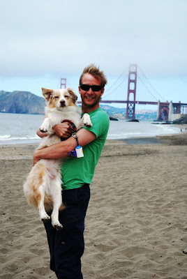
Off we went south on 101 with Yosemite as our final destination for the day. We had several possible routes, but we finally decided that as part of this trip we just had to pay the 6 bucks and drive over the Golden Gate Bridge. It was a PERFECT San Francisco day with low clouds.... the bridge was very picturesque with one of the towers lost in the clouds.

We hadn't really planned on spending any time in SF -- we've both been there several times -- but it really is just such a cool city, that we again adjusted our schedule and decided to poke around town for some photo ops and slow cruising.
 This really nice girl scout took our photo here.... We have one where everyone is looking at the camera and it's perfect -- except that the bridge is cut off. This will not be the last time I get frustrated by people taking our photo and not having any idea about image composition, lighting, etc... but I digress.
**********************
Garmina, our trusty Garmin Nuvi GPS decided to route us out of San Francisco towards Yosemite by way of ...... downtown. Awesome. We sat in downtown SF for about 90 minutes before finally getting on the Bay Bridge towards Oakland. Fast forward a whole bunch more traffic (although, it really is/was/will be the only traffic of the entire trip), and we saw this pretty view just east of Oakland (shot from the car at 65mph):
We roll in to Groveland, CA that evening and set up camp for a two night stay about 20 minutes outside of the park. The park reservation-only campgrounds were all full and the walk-in campgrounds don't allow dogs (ie. Camp 4). It actually worked out great anyway... our site was kind of expensive (we got a site with electricity hoping we could blog and watch hulu etc, but once again (and not for the last time) we were frustrated by the lack of bandwidth of so called "wifi" at the campground.... hence the huge back log of blogging.
Lorin did a fantastic job of planning our Yosemite itinerary. We were there on a Friday / Saturday, and had been plenty warned about the intense congestion, traffic and all around Griswold-ness of the park. Both days we got up very early and basically had the park to ourselves for the entire morning. It was amazing.... very peaceful, tranquil and beautiful. By about 11am, however, all the gumbies had arisen, had their breakfasts of red bull, bacon and Miller Lite and made a mess of the Merced River and the Valley in general.
Lorin had picked out a hike for us... the "4 mile trail". We hit the trail by 7:30am, with no one in sight. Dogs are allowed on paved trails only in National Parks, and this trail was close enough to being paved (it had been paved years and years ago, and was sort of half-paved now) that we figured we could argue it if a ranger questioned us. It was an awesome trail, straight up about 2,000 feet, and actually is mis-named... it's 4.6 miles ---- one way.
Here's some photos from the hike:
Yosemite Falls


Bridal Veil Falls.... very cool, but again, we went towards the end of the day and there were a bunch of crying babies, shuffling fat people etc etc. I am getting really good at comprising my photos by carefully cropping out all the tourists.

Ok. This is pretty much the most incredible view I have ever seen. The whole valley all the way up to Tanaya Valley. I would love to come back and do some backcountry hiking in the Tanaya Valley.
We continued driving up and around the valley to Glacier Point and Washburn Point for the epic view of Half Dome:

And on the way back down to leave the park for the day, we came across this astounding view point that put Half Dome and El Cap almost perfectly in line. This was a little pull out that didn't seem to get much action, compared to the "Tunnel Viewpoint" that we stopped at on the way up. This was actually one of my favorite views of the day (although they were all spectacular).

It was a pretty incredible day... very long day with a 9 mile, 4k ft hike in the middle, but getting up early was so refreshing and peaceful.
Oh, and we cooled off at lunch in the Merced River where we saw an intense tourist scene of hundreds of people on tubes, swimming, drinking bridge jumping etc... it was crazy. We much preferred our early morning hike.


No comments:
Post a Comment